Friday, June 24, 2011

Baker, MT to Hettinger, ND

Today we said goodbye to Montana and hello to North Dakota. Cal has ridden 798 miles in Montana.


Oil Storage Tanks with Wind Generators in the Background
Tonight, our only night in North Dakota is in Hettinger – along Hwy 12. Hwy 12 again follows another BNSF rail line. Cal rode 85 miles today.  As I wrote before, yesterday the wind was out of the east and would have been in Cal’s face had he ridden yesterday.  Last night a storm passed through (). Within minutes after it began to rain, the wind shifted so it was coming out of the west.  This morning was clear, sunny and a lovely temperature. 

Hwy 12 is on the very south end of the N Dakota Badlands. We did see some unique formations.
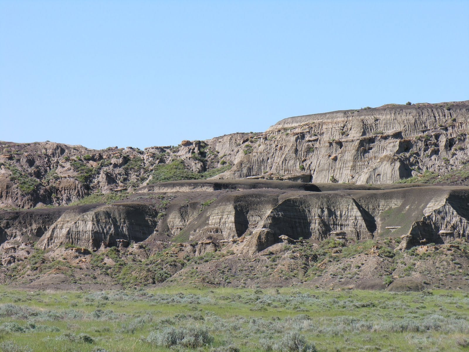
Southern Edge of the North Dakota Badlands

Mushroom Formations in the North Dakota Badlands

Other than these North Dakota Badland formations, when it is not wheat fields, it was grazing for cattle.

The last few days I have been able to dispose of magazines, after I have read them!  The little towns hardly have a convenience shop, much less anything else to do.  I have been driving ahead of Cal approximately 10 miles, stopping, and reading until he catches up.  By coming south in Montana we have avoided the mosquitoes and the gnats. It is so nice to be able to open the windows while I am waiting for Cal, something I could not do farther to the north.

Storms are predicted for tonight, with wind out of the east, but by morning the wind is to be out of the west again. Bikers are very aware of the wind direction and are always looking which way the flag is blowing.

Once Used Elevator along the BNSF Rail Line

Baker, MT – Rest Day:

This is the Thursday June 23, 2011 blog which was posted Friday June 24, 2011.


Sleeping-in was great this morning.  It was a lovely day, sunny and temp in the 70’s, however the wind was definitely out of the east! At 20-25 mph! A rest day was perfect timing.  If Cal had been riding it would have been a very tough day with the strong wind. 

Baker has one blinking stop light in the middle of town.  It is a small county seat town which serves a wide area.  We found 2 laundry mats, and a good sized grocery store. It is great to have clean clothes again, and restocked with groceries.

Within a block of the main highway passing through town, there is a lovely lake.  The town has spent time and money in developing this lake area into a great outdoor spot - walking path, picnic areas, etc.  We picked up lunch items and drove out to the lake – used one of the shelters built as an Eagle Scout project. Canadian Geese with their young were on the lake. While eating lunch we decided we would return to the lake to cook our evening meal.

Canadian Geese on Lake Baker at Baker, MT

Dinner by Lake Baker at Baker, MT

After lunch we drove around town and then north of town again, to where the oil activity is located.  At the moment there is no new drilling in this immediate area, but they have been doing more exploration, so additional drilling is expected in the near future. At this time all new drilling is occurring in North Dakota - 175 drilling rigs in operation.  It is thought the ND oil field could be as large as the one in Kuwait. As I said yesterday the amount of oil that is pumped depends on the economics of it.    

This afternoon after a nap, reading, emailing, and relaxing, we picked up evening meal items and returned to the lake.  While by the lake two different sets of people came to the lake with their paddle boats. It was a beautiful evening, but breezy. 

The forecast for the next few days is rain!!!  We will see what happens, how bad it is! But the wind is supposed to be out of the north northwest.  We are going to follow Hwy 12 east.  In South Dakota Hwy 12 turns slightly southeast to Mobridge where we will cross the Missouri River.

Wednesday, June 22, 2011

Glendive, MT to Baker, MT


Yes, I know today was going to be a rest day!  Last night before we turned off the lights Cal looked at the weather forecast for today and the next several days.  Today (Wed) the wind was to continue blowing out of the west northwest, tomorrow (Thurs) it will be blowing out of the south southeast.  Cal is riding to the south southeast and he does not want to ride into a headwind, so late last night plans changed.  He rode 70 miles today and we will take a day off in Baker. 

The morning was clear, sunny, and a perfect temperature.  As soon as we left the motel in Glendive Cal began riding along I-94.  Yes, in Montana you are able to ride your bike on the Interstate Hwys. There is a smooth wide shoulder and things went well.  Montana’s I-94 does not have much traffic in comparisons to Interstates elsewhere. 
Riding Along I-94 east of Glendive, MT


Riding Along I-94 east of Glendive, MT


After exiting the Interstate the terrain was fairly level for the first 16 miles, however then things changed.  It was up and down, but mostly up! Cal gained a 1000 ft in elevation on his way to Baker. Again today we travel through all agriculture area – pasture and Angus herds, wheat, more wheat, and hay.

Montana Wheat Fields

A Gravel Road toward a Town over the Ridge
Montana Angus on the Range


Montana Angus on the Range near a Windmill

Angus Cattle Cooling in the Water


As we came over a ridge approx. 5 miles north of Baker, MT, all of a sudden there were oil wells, everywhere.  Baker is an Oil Boom town right now.  It is unreal all the industry related to oil and the oil depots in this area.  We had no idea! However at dinner tonight we were talking to an electrician who is working on a job in the area right now and he said this oil business is interesting. They are continually drilling and capping, and only when the price is high enough do they actually pump it out of the ground. If the price of crude is $100 they are pumping!  He was surprised we had found a motel in the area.  In these oil areas, you can hardly find accommodations – even a house to rent. A group of guys working in the oil fields may be living together in one house, splitting the rent.  One waitress said that the houses may be trashed when they leave, but you have charged a substantial amount for rent. Last night in Glendive, we were one of the few non-pickup vehicles parked in the motel parking lot.  In Montana you need a pick up to haul the hay or the testosterone!

Oil Well North of Baker, MT
So tomorrow we will relax here in Baker.  The town is actually larger than I expected, but that doesn’t mean there is anything to do here!!  One of the BNSF rail lines comes through so there are several grain elevators as well as oil depots. 

Cal has ridden 1400 miles so far.  700 of them have been in Montana.  This is a huge state! It is said that it is nearly as far from the northwest corner of Montana to the southeast corner of the State, as it is from Chicago to New York City.  Another little known fact is that the western tip of Virginia is as far west as Detroit. And the southern tip of the Great Lakes are as far south as Northern California. 

Our daughter who works and lives in the Middle East has commented on the clouds in the photos I have taken.  Yes, the skies/clouds are beautiful and I suppose thus their State’s nickname.  “Big Sky Country”!

Baker is 12 miles from the North Dakota border – that is the very southwest corner of North Dakota.  We figure we will have 1 ½ days in North Dakota, so by the end of the week we will be in South Dakota. Honestly each day we chip away another chunk of miles, and we will be home to eastern Iowa before we know it.     

Wolf Point, MT to Glendive, MT

We are still in Montana – seems like this State will not stop!  However we have started our southward swing.  Tonight and tomorrow we will spend here in Glendive, MT.  It is time for Cal to have a rest day.  The waitress tonight said there isn’t anything to do in Glendive, but our next stop is Baker, Mt which has less to do!! So we are staying here for our rest day. 

This morning soon after I dropped Cal at the place where I picked him up last night, I was probably 4 miles ahead of him, when just up the hill in front of me two adult mule deer with what I think were twin fawns crossed the road. I had not yet taken the camera out of the case, so till I stopped and had the camera ready, they were well down in the wheat field. However here is the photo I did shoot of them.

Mule Deer, One Female Appears to have Twins
Today while on the Big Sky Byway we passed the Montana Badlands. It is a relatively small area, but nether-the-less similar topography as the Dakota Badlands.

Montana Bad Lands

Half of today’s the route followed a railway. When a road follows railroads the grades are more level and any climbs are more gradual. The first part of the day was on a route cross country – the road was up and down over each ridge in the landscape, so Cal was ready for something more level. 

Railway with Wooden Tressel
Again late this afternoon there was another rain storm. This time we saw three rainbows – not all at the same time.  While the first one was dim a second one developed.  It was very unique.  It basically was horizontal– It was on the horizon – the horizon shone with color and later it did create an arch.  Later there was a nice sunset. 

Another Afternoon Montana Rain Storm


Another Afternoon Montana Rain Storm

Monday, June 20, 2011

Glasgow to Wolf Point

Tonight we are in Wolf Point, a town on the Fort Peck Indian Reservation, and we just witnessed the most unusual rainbow.  It was pouring rain and at the same time the sun was shining, so I began looking for a rainbow.  I can say this rainbow was brightest, fullest one I have ever seen, plus it was a double rainbow.  However the second one was not as bright as the main one. The interesting things was it that it lasted for at least 20 minutes, and after that we could still see pieces of it.

Double Rainbow over Wolf Point, MT

Double Rainbow over Wolf Point, MT
Today was another beautiful day for riding.  The sun was shining, it was not too hot, and no rain. 
We continued to see more flooding from the Missouri River.

Flooded Milk River near Nashua, MT


Flooded Milk River near Nashua, MT


I arrived at Wolf Point before and checked into the motel we had reserved.  It was approx when Cal arrived after only riding 50 miles.  We had a light lunch and he continued riding, turning south at this point.  He began riding the Big Sky Back Country Byway.  It begins just south of the Ft Peck Reservation and goes through beautiful rolling countryside.  The farmsteads look prosperous. Cal wanted to ride part of this route this afternoon, so his day tomorrow will be more manageable - 70 miles instead of 95 miles, until we reach our overnight destination town.  

At this afternoon I drove to where Cal was located and brought him back to Wolf Point.  We really expected this type of scenario to occur more often, but this is the first.  

Not much else happened today!


Farm Land along the Big Sky Back Country ByWay

Malta to Glasgow (70 miles):

Photos added on the morning of June 20, 2011

Another 70 miles down today! There was cloud cover all day, with only a few sprinkles of rain. The temperature began in the mid 50's and ended in the 70’s.  In fact when we arrived at the motel I immediately changed into capri pants and sandals! Felt great!!

The day has been interesting in that we have been informed of the difficulty in finding motel accommodations in northeast Montana and northwest/north central North Dakota.  There are oil fields in these areas so the oil companies have all the hotels/motels reserved during the week.  Today I called ahead to where we anticipated arriving the next few nights, only to be told, “We are booked”.  Everyone told me the same story “Oil workers”. Tonight we have been working on a new route, and booking motels, so that we do not have to camp with the swarms of mosquitoes and black gnats!

Tomorrow we are going to stay in Wolf Point along Hwy #2, however Cal plans to ride farther than that point as he wants a longer day, then I will pick him up and we will drive back to Wolf Point for the night. At Macon on Hwy 2 we plan to turn south on Hwy 13 (the Big Sky Back Country Byway) and go toward Glendive, MT.  At that point we will turn east.  Yes, Cal will be riding on the shoulder of I-94 for 28 miles – very legal in Montana.  We will just catch a little portion of southwest North Dakota before reaching South Dakota. 

By doing this route change we will also be missing a lot of the flooding in North Dakota.  We will have to be careful regarding this in eastern South Dakota along the Missouri River. 
As to flooding – today we saw massive flooding from the Milk River which flows into the Missouri River. We have been told this area received an unusually large amount of snow this winter.  A lot of this water came from snow melt and now it rains almost everyday.  They are so tired of all the rain.  This evening we drove to Fort Peck Dam.  According to locals, Fort Peck Lake has never been this full.  They are opening the spillway for a huge amount of water to go down the Missouri River.  Tonight we drove by the completely flooded Little League fields here in Glasgow. With all the excess water it is no wonder there are all the swarms of flying insects.
Flooded Glasgow, MT Baseball Field


Milk River Flooding near Glasgow, MT


Fort Peck Earthen Dam - 4 miles long


Spillway for the Fort Peck Dam


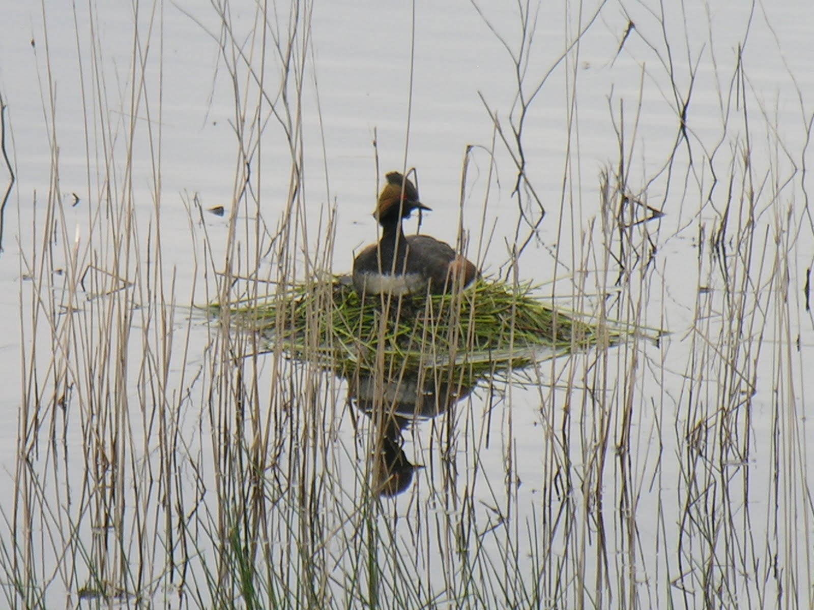
Eared Grebe on nest in Saco, MT Flats Marsh


Saturday, June 18, 2011

Havre to Malta, MT (92 miles)

Most of you know Cal and I have had some international experiences.  We did not realize this trip would be as international as it has been in the past two days.  We have been to the Kremlin (Russia), Zurich (Switzerland), Malta (the island); Dunkirk (France) Devon (UK), Inverness (Scotland & New Zealand); and here in the States, Harlem (NY), and Fresno (CA).  Cal and I have been to all of these international locations except Malta, but our daughter has been there in the past year.  All of these are towns in Montana and we have driven through then on Hwy 2. 

We know in Minnesota you can buy tee shirts declaring “the Minnesota State Bird is the Mosquito”, however I am not sure that northern Montana cannot say the same!  Cal is trying to outrun them, and I keep the windows closed on the vehicle.  I have never seen mosquito’s swarm around a vehicle like they do here. Any time I stop they are all around. Is it true they are attracted to light colors?  So even if the temperature does warm up, I am not camping with these mosquitoes.

All day we followed the Milk River (its origin is in Canada). Being in the river valley, the ride continued to be fairly level, the temperature was almost perfect for riding, and since there was a tail wind Cal rode 92 miles. This was in spite of a 5 mile construction zone, and a 20 minute break for the daily rain storm.  It rains sometime everyday - (as I am writing, another rain storm is passing over us and I can see a rainbow from where I am sitting). We saw more extensive flooding today.
Result of Montana Flooding

Passing Rain Storm Clouds

Countryside near Malta, MT

Montana Horse Ranch
Today I took photos of several buildings who outlived their usefulness.  It would be interesting to know information about these buildings.  Who has lived there; when and how long they lived there; the origin of the residents; how many children lived there; and there are many more questions.  ‘If only those walls could talk’! 
Abandoned school


Two Mule Deer Posing for Rachel's Photo